Vr Mapping |
ON-LINE REFERENCE DOCUMENTATION CARDINAL SYSTEMS, LLC |
Delete Close Points (DelClo)
Type: Batch Application
Modifies symbols, text or VrPoints (LiDAR) that fall within a user defined distance from lines, points on lines, symbols and (or) text label origins.
Detailed Description
Searches lines, points on lines, symbols and/or text label origins in user-defined layers and deletes, re-layers, or re-classifies points that are within a user-defined distance to these entities. Points may be symbols, text or Vrpoints (LiDAR), and they may be deleted, moved to another layer or re-classified. Re-classification is considered only when VrPoints are specified. Delete Close Points is useful for deleting DTM and LiDAR points that are too close to DTM break lines.
Layers that are turned off will not be considered even if specified. Delete Close Points is undoable for symbols and text but not for points.
Available Key-ins
Key-in |
Description |
Range |
PARFIL= |
Load parameter file |
Delete Close Points parameter file name (.dcp) |
RUN |
Run Delete Close Points |
|
Parameters for Line Close Points
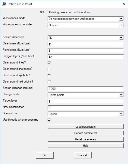
Workspaces mode
Determines if symbols, text or VrPoints should be tested against lines that are not in the same layer.
Workspaces to consider
Defines the workspaces to consider.
Search dimension
Dimension to use when searching for entities to change. The Search Dimension options are 2D or 3D.
Clear layers
Defines the line layers to check against the points. This may be entered as a number line. Layers that are turned off will not be considered even if specified.
Point layers
Defines the point layers to check against the line layers. These layers may contain symbols, text, or VrPoints. This may be entered as a number line. Layers that are turned off will not be considered even if specified.
Polygon layers
Defines the layer or layers that contain polygons defined as VrLines and will further filter points to be deleted/modified. If defined, points to be delete/modified must be within the search distance of a line in the "Clear layers" and must fall within one of the user defined polygons. This is an optional parameter and may be left blank to turn off this feature. The Polygon layers may be entered as a number line.
Clear around lines
Deletes, re-layers symbols, text or deletes, re-layers or re-classifies VrPoints that fall within the search distance of any part of a line.
Clear around line points
Deletes, re-layers symbols, text or deletes, re-layers or re-classifies VrPoints that fall within the search distance of any line vertex.
Clear around symbols
Deletes, re-layers symbols, text or deletes, re-layers or re-classifies VrPoints that fall within the search distance of any symbol origin.
Clear around text
Deletes, re-layers symbols, text or deletes, re-layers or re-classifies VrPoints that fall within the search distance of any text origin.
Search distance
Defines the search distance. Symbols, text or VrPoints that fall within this distance from the lines specified will be deleted or moved or re-classified (VrPoints). This value is entered as ground units.
Change mode
Defines the action to take on points that fall within the search distance of the lines specified. Options are “Delete points”, “Move points to target layer”, and "Change classification (VrPoints). If "Move points to target layer" is selected the points will be moved to the target layer as defined by the Target layer field. If "Change classification" is selected, the VrPoints will be re-classified to the classification number defined in the New classification field.
Target layer
If the Change mode is set to “Move points to target layer”, this parameter defines the layer to which to move the points.
New classification
If the Change mode is set to "Change classification (VrPoints), this parameter defines the classification number to which to change the qualifying VrPoints.
Line end cap
When comparing symbols, text or VrPoints against lines, the end cap parameter determines if points past the ends of the line will be considered. The End Cap options are Round or Flat.
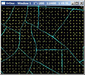
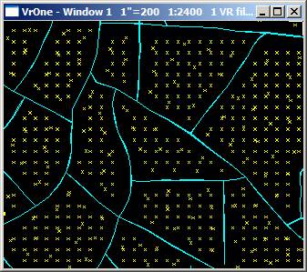
In the examples below, VrPoints within 3 feet have been re-classified and the Round end cap option on the left and the Flat end cap option on the right.
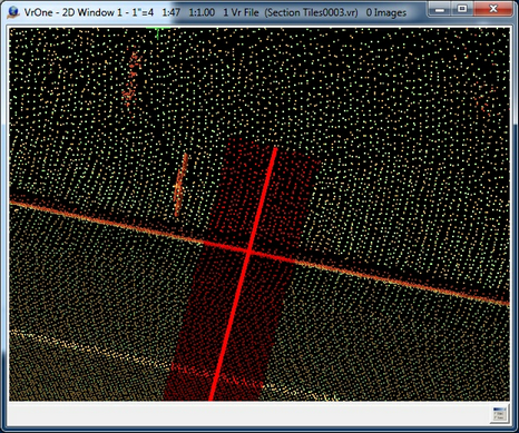
End Cap options. Round end cap is on the left and Flat end cap is on the right.
Use threads when processing
The use of threads can improve processing performance when processing VrPoints against lines. The performance of threading depends on the number of CPUs and (or) number of cores on each CPU that available in the computer.
Version 05.09.03 - 28-Aug-2017 - Added "Polygon layers" option