Vr Mapping |
ON-LINE REFERENCE DOCUMENTATION CARDINAL SYSTEMS, LLC |
Miscellaneous Reference
Mapping Accuracy
NMAS – National Map Accuracy Standards
ASPRS – American Society for Photogrammetry and Remote Sensing
C-Factor
Cf = H/Ci
Where:
Cf = C-Factor
Ci = Contour interval (feet)
H = Flying height (feet) above mean ground level
Maximum ASPRS and Interpolated NMAS-C Factors
Map Accuracy Standard |
Softcopy Workstation |
Analytical Stereoplotter |
ASPRS Class 1 |
1600 |
2000 |
NMAS |
1700 |
2100 |
ASPRS Class 2 |
1800 |
2200 |
ASPRS Class 3 |
2000 |
2500 |
Source: Aerial Mapping methods and applications / Edgar Falkner and Dennis Morgan – 2nd edition – Lewis Publishers
Maximum Recommended Enlargement Factors from Photo Scale to Map Scale
Map Accuracy Standard |
Softcopy Workstation |
Analytical Stereoplotter |
ASPRS Class 1 |
6.0 |
7.0 |
NMAS |
6.5 |
7.5 |
ASPRS Class 2 |
7.0 |
8.0 |
ASPRS Class 3 |
8.0 |
9.0 |
Source: Aerial Mapping methods and applications / Edgar Falkner and Dennis Morgan – 2nd edition – Lewis Publishers
Film Strip Location
Film Strip Location – Zeiss RMK TOP
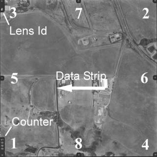
Source: Z/I Imaging – Denver Co.
Film Strip Location – Wild RC10/20/30
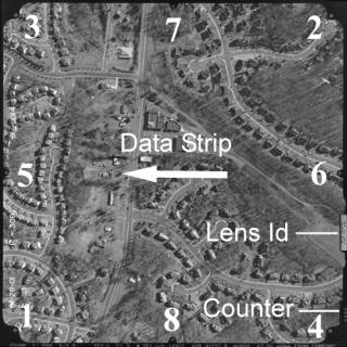
Source: USGS Optical Science Laboratory