Vr Mapping |
ON-LINE REFERENCE DOCUMENTATION CARDINAL SYSTEMS, LLC |
Tile Points (TilPoi)
Type: Batch application
Tiles VrPoints (LiDAR) from multiple VrOne files and creates new VrOne files.
Detailed Description
Tile Points is useful when LiDAR data management requires a project or group of files to be arranged in a manageable tile format. Multiple VrOne files containing VrPoints (LiDAR) are used as input and new VrOne files are created with each new file containing one geographic tile of point data.
Available Key-ins
None
Parameters for Tile Points
On starting Tile Points, a dialog is displayed in which the input VrOne files are defined.
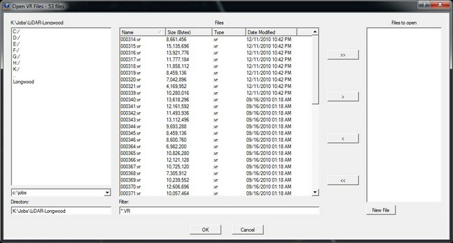
VrOne input file selection dialog
Select the VrOne files to use as input for the tiling process. Multiple files may be selected. Any files that are currently open in VrOne or VrTwo will be closed before the tiling process starts.
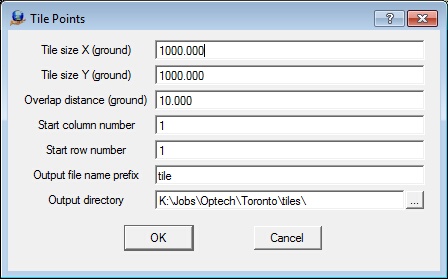
The Tile Points parameter dialog
Tile size X (ground)
Defines the tile size for the X axis in ground units.
Tile size Y (ground)
Defines the tile size for the Y axis in ground units.
Overlap distance (ground)
Tiles will overlap adjacent tiles by this amount and the data in the overlap areas will be duplicated.
Start column number
The new VrOne files that are created from this process will contain a file name prefix and the column (X) and row (Y) number for each tile. This parameter defines the start column number.
Start row number
The new VrOne files that are created from this process will contain a file name prefix and the column (X) and row (Y) number for each tile. This parameter defines the start row number.
Output file name prefix
Defines a file name prefix for the output file names.
Output directory
The files created by Tile Points may be placed in a user defined directory. The directory must exist before running this batch application.
Once the parameters are entered and OK is pressed, the tiling process is performed. The start coordinates for the tiling are rounded in the X and Y direction to an even interval of the tile size and the results are displayed in the Command Prompt window. The following is an example of the results from Tile Points.
Coordinate Range
Minimum 461082.050 3170998.270 10.660
Maximum 469082.040 3177998.260 104.980
Start Tile 461000.000 3170000.000
Number columns 9
Number rows 8
Number tiles 72
The output file names consist of the file name prefix and the column and row numbers such as:
Tile001001.vr
Tile001002.vr
Tile001003.vr
Tile001004.vr
Tile001005.vr
Tile001006.vr
Tile001007.vr
Tile001008.vr
Tile002001.vr
Tile002002.vr
Tile002003.vr
Tile001004.vr
...