Vr Mapping |
ON-LINE REFERENCE DOCUMENTATION CARDINAL SYSTEMS, LLC |
XML Out (XmlOut)
Type: Translator
Translates VrOne lines and symbols into a XML (Extensible Markup Language) file and is based on the LandXML schema
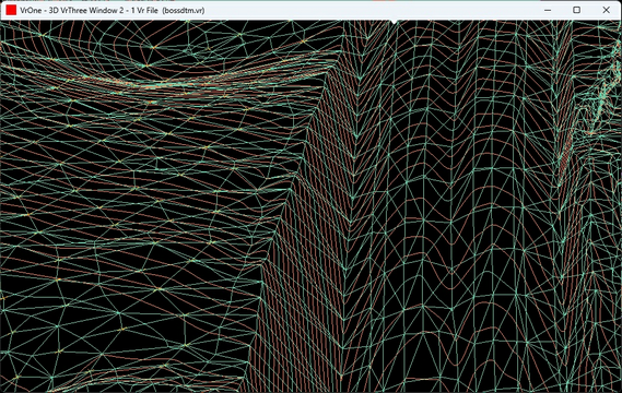
DTM Surface
The LandXML schema is usually used to represent surface data (ground or topography of terrain). XML Out includes the translation of Vr Symbols and Vr Points (LiDAR). Both of these entity types are translated using the coordinate position and no other attributes are translated. The LandXML schema is not designed for storing and displaying point cloud data or individual point coordinates. Even though LiDAR coordinate positions can be translated, it is recommended that LAS Out is used to translate LiDAR data. The LAS format is specifically designed for efficiently representing point cloud data.
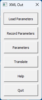
The XML Out button box.
Loads previously recorded XML Out (.xmo) parameter file.
Records current translation parameters to a XML Out (.xmo) parameter file.
Allows editing of the translation parameters.
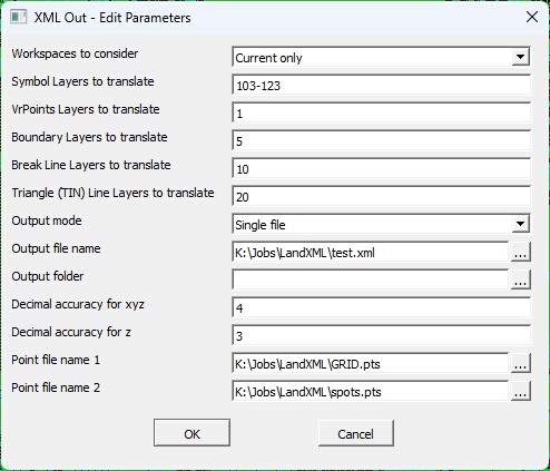
The Edit Parameters dialog box
Workspaces to consider
Defines the workspaces to consider when exporting XML Out files. Options are "Current only" and "All open".
Symbol Layers to translate
Defines the symbol layers in the VrOne file(s) to translate. A Number Line may be used to define these layers. Symbols are defined using the LandXML CgPoints element with the "Symbols" attribute. If this field is empty, symbols will not be translated.
VrPoints Layers to translate
Defines the VrPoints layers in the VrOne file(s) to translate. A Number Line may be used to define these layers. VrPoints are defined using the LandXML CgPoints element with the "VrPoints" attribute. If this field is empty, VrPoints will not be translated.
Boundary Layers to translate
Defines the layers containing boundary lines in the VrOne file(s) to translate. A Number Line may be used to define these layers. Boundary lines are defined using the LandXML Boundary element. If this field is empty, boundary lines will not be translated.
Triangle (TIN) Line Layers to translate
Defines the layers containing triangle lines that define a surface in the VrOne file(s) to translate. A Number Line may be used to define these layers. The three coordinate positions of each triangle is used to create a LandXML surface using the Pnts and Faces elements. A DTM surface must be created in VrOne using SetDtm and RunDtm with the Legs Layer defined. The Legs Layer should be used as the Triangle Line Layer. If this field is empty, triangle lines will not be translated.
Break Line Layers to translate
Defines the layers containing break lines in the VrOne file(s) to translate. A Number Line may be used to define these layers. If this field is empty, break lines will not be translated.
Output mode
Determines handling of output files during translation.
| • | Single File - All open workspaces are translated into a single XML file. The "Output file name" field determines the output file name. The "Output directory" field may be used to place the output file in a different folder than the VrOne file. |
| • | One File Per Workspace - A XML file is created for each open workspace. The output filename is the same as the workspace (VrOne) filename with a .xml extension. The "Output directory" field may be used to place the output files in a different folder than the VrOne files. |
Output file name
Defines the output file name when "Output mode" is set to "Single File". This name is ignored if "Output mode" is set to "One file per workspace". The file extension for a XML file is ..xml
Output folder
Defines the folder name to place the output file(s). This field may be left blank to place the output files in same the directory as the VrOne files.
Decimal accuracy for xy
Defines the number of decimal places for the x, y coordinates in the output file(s).
Decimal accuracy for z
Defines the number of decimal places for the z coordinates (elevation or altitude) in the output file(s).
Point file name 1
File name for an existing ASCII point file. The format of this file is determined by the software translating the XML file(s).
Point file name 2
File name for an existing ASCII point file. The format of this file is determined by the software translating the XML file(s).
Linear Unit
Allows for the definition of the Linear Unit (linearUnit=) attribute in the Units Element in the output file.

Linear Unit Attribute Dialog
| • | Linear Unit - Defines the Linear Unit. Options include Foot, USSurveyFoot, Inch, Mile, Millimeter, Centimeter, Meter, Kilometer, and Custom. If Custom is selected then the string defined in the Custom Linear Unit String parameter is used. |
| • | Custom Linear Unit String - If the Linear Unit is set to Custom them this text string will be used as the Linear Unit. |
Begins the file translation process. Upon completion, XML (.xml) file or files will be created.
Starts the browser and displays the current help document.
Quits XML Out and allows current parameters to be saved if they were altered.
XML Out (XMLOut) added June 2023 - Version 07.01.20
Added Linear Units definition - January 2025 - Version 07.01.24