Vr Mapping |
ON-LINE REFERENCE DOCUMENTATION CARDINAL SYSTEMS, LLC |
Delete Points in Polygons (DelPoi)
Type: Batch Application
Deletes or changes layers of points (symbols and text entities and VrPoints (LiDAR)) that are inside polygons.
Detailed Description
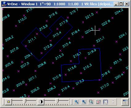
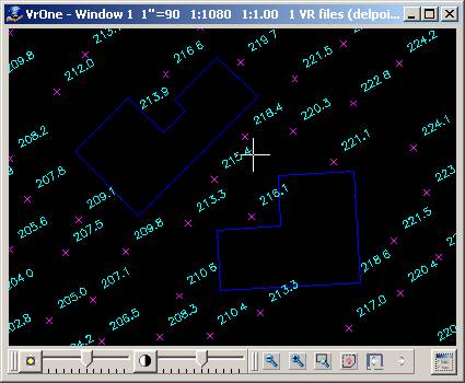
Searches polygons in user-defined layers and deletes points that fall inside the polygons. Points may be symbols, text labels, and VrPoints (LiDAR). Points may be deleted or moved to another layer.
Layers that are turned off will not be considered even if specified. Delete Points in Polygons is undoable.
Available Key-ins
Key-in |
Description |
Range |
PARFIL= |
Load parameter file |
Delete Points in Polygons parameter file name (.dpp) |
RUN |
Run Delete Points in Polygons |
|
Parameters for Delete Points Inside Polygons
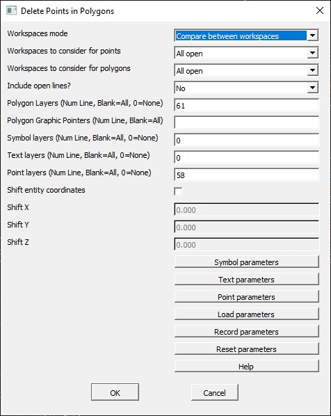
Workspaces mode
Defines the workspace compare mode.
Do not compare between workspaces |
Points are only be compared against polygons in the same workspace. |
Compare between workspaces |
Points are compared to polygons in other workspaces. |
Workspaces to consider
Defines the workspaces to consider. If workspaces mode is set to “Do not compare…”, this option is displayed, and applies to points and polygons.
Workspaces to consider for points
Defines the workspaces to consider for points (symbols, text). If workspaces mode is set to “Compare between…”, this options is displayed. This allows the workspaces to consider for points to be set separately from the workspaces to consider for polygons. For example, the user may want to only search the current workspace for points, but compare the points to polygons in all open workspaces.
Workspaces to consider for polygons
Defines the workspaces to consider for polygons. If workspaces mode is set to “Compare between…”, this options is displayed. This allows the workspaces to consider for polygons to be set separately from the workspaces to consider for points. For example, the user may want to only search the current workspace for points, but compare the points to polygons in all open workspaces.
Include open lines
Determines if open lines should be treated as polygons.
Yes |
Open lines are considered polygons by assuming a closing segment between the last and first points. |
No |
Only existing polygons (closed lines) are considered. |
Polygon layers (Num Line, Blank=All, 0=None)
Defines the polygon layers against which to check points. This may be entered as a number line. If left blank, all layers are considered. If set to zero, no layers are considered. Layers that are turned off are not considered even if specified.
Polygon graphic pointers (Num Line, Blank=All)
Defines the polygon graphic pointers against which to check points. This may be entered as a number line. If left blank, lines with any graphic pointer are considered.
Symbol layers (Num Line, Blank=All, 0=None)
Defines the layers in which to search for symbols inside the polygons. This may be entered as a number line. If left blank, all layers are considered. If set to zero, no layers are considered. Layers that are turned off are not considered even if specified.
Text layers (Num Line, Blank=All, 0=None)
Defines the layers in which to search for text inside the polygons. This may be entered as a number line. If left blank, all layers are considered. If set to zero, no layers are considered. Layers that are turned off are not considered even if specified.
Point layers (Num Line, Blank=All, 0=None)
Defines the layers in which to search for VrPoints (i.e. LiDAR) inside the polygons. This may be entered as a number line. If left blank, all layers are considered. If set to zero, no layers are considered. Layers that are turned off are not considered even if specified.
Symbol parameters [Button]
Symbol graphic pointers (Num Line, Blank=All)
Defines the symbol graphic pointers to search for. This combined with the Symbol layers specified above will define the symbols to consider. The Graphic Pointers may be entered as a Number Line. If left blank, all Graphic Pointers will be considered
Shift entity coordinates
If checked and an entity type (symbols, text, and/or points) is has its change mode set to "Move to target layer" or "Don't change layer" then these entities will be shifted by the amount defined by Shift X, Shift Y, and Shift Z.
Change mode for symbols
Defines the action to take on symbols to be considered that fall within the polygons.
Delete |
Delete the symbols. |
Move to target layer |
Move the symbols to the target layer as defined by “Target Layer for Symbols” and “Target layer mode for Symbols”. |
Don't change layer |
If the symbols are to be shifted only then this item should be selected. |
Target layer mode for symbols
Determines how the target layer for symbols is used when “Change mode for symbols” is set to “Move to target layer”.
Set to target layer |
The symbol layer is changed to the “Target layer for symbols”. |
Add to target layer |
The “Target layer for symbols” is added to the existing symbol layer to compute a final target layer for the symbol. The symbol layer is changed to the computed target layer. |
Target layer for symbols
If the Change mode for symbols is set to “Move to target layer”, this parameter defines the layer to which to move symbols. The Target layer mode for symbols determines how this number is used to determine the final target layer.
Text parameters [Button]
Change mode for text
Defines the action to take on text that falls within the polygons.
Delete |
Delete the text. |
Move to target layer |
Move the text to the target layer as defined by “Target Layer for Text” and “Target layer mode for Text”. |
Don't change layer |
If the text labels are to be shifted only then this item should be selected. |
Target layer mode for text
Determines how the target layer for text is used when “Change mode for text” is set to “Move to target layer”.
Set to target layer |
The text layer is changed to the “Target layer for text”. |
Add to target layer |
The “Target layer for text” is added to the existing text layer to compute a final target layer for the text. The text layer is changed to the computed target layer. |
Target layer for text
If the Change mode for text is set to “Move to target layer” this parameter defines the layer to which to move text. The Target layer mode for text determines how this number is used to determine the final target layer.
Text parameters [Button]
Change mode for points
Defines the action to take on points (LiDAR) that falls within the polygons.
Delete |
Delete the points. |
Move to target layer |
Move the points to the target layer as defined by “Target Layer for points" and “Target layer mode for points". |
Add to target layer |
The “Target layer for points is added to the existing text layer to compute a final target layer for the point. The point layer is changed to the computed target layer. |
Target layer mode for points
Determines how the target layer for points (LiDAR) is used when “Change mode for points” is set to “Move to target layer”.
Set to target layer |
The points layer is changed to the “Target layer for points”. |
Add to target layer |
The “Target layer for points” is added to the existing points layer to compute a final target layer for the point. The points layer is changed to the computed target layer. |
Target layer for points
If the Change mode for points (i.e. LiDAR) is set to “Move to target layer” this parameter defines the layer to move points to. The Target layer mode for points determines how this number is used to determine the final target layer.
Load parameters [Button]
Loads the parameters from a previously recorded parameter file.
Record parameters [Button]
Records the current parameters to a parameter file. This file will automatically be loaded when Delete Points in Polygons (DelPoi) is started again.
Reset parameters [Button]
Resets the current parameters to default values. NOTE: Parameters that have not been recorded (saved) will be lost.
Help
Displays this help page.
Revised October 2022