Vr Mapping |
ON-LINE REFERENCE DOCUMENTATION CARDINAL SYSTEMS, LLC |
Drape To Points (DraPoi)
Type: Interactive/Batch Application
Detailed Description
Drapes line points and/or symbols to existing VrPoints (LiDAR). The line points and symbols are identified by a user-defined boundary polygon. An existing polygon may be identified or a temporary polygon may be digitized as the boundary polygon. Options include generating a grid of symbols in the boundary polygon before draping.
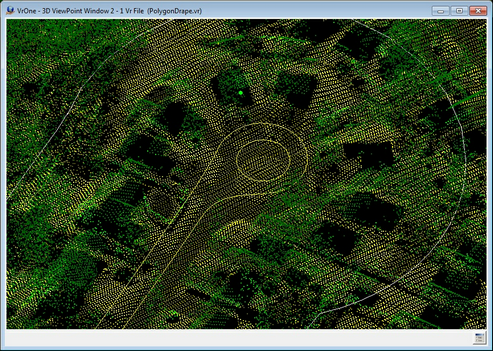
Drape example - before
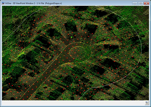
Drape example - after
The example above shows an area delineated by a user defined polygon (white line). The "before" screen shot shows the user-defined polygon along with a road edge. The elevation of the road is above the surface defined by the points (LiDAR). The "after" screen shot shows the road edge draped onto the surface and the addition of a grid of symbols that is also draped onto the surface.
Button Assignments
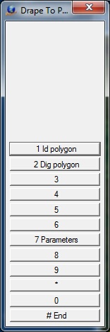
The Drape To Points Menu Keys
Drape Polygon – Main
|
Button |
Description |
1 |
Id polygon |
Identifies an existing polygon as the boundary. |
2 |
Dig polygon |
Allows the boundary polygon to be digitized. The Insert Line application is used to digitize the line. The resulting line is not saved after processing |
3 |
|
|
4 |
|
|
5 |
|
|
6 |
|
|
7 |
Parameters |
Allows the definition of Drape to Points parameters (see below). |
8 |
|
|
9 |
|
|
* |
|
|
0 |
|
|
# |
End |
Ends application. |
Parameters
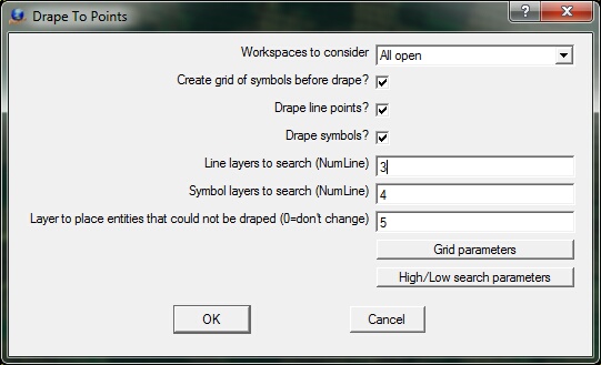
Drape To Points parameter dialog
Workspaces to consider - Defines the workspaces to consider when identifying points for change. This may be set to "Current only", or "All Open".
Create grid of symbols before drape? - Allows the creation of a grid of symbols that are placed at the user defined increment. The initial elevation of the symbols is defined by the first point of the boundary polygon. See "Grid parameters" below for the definition of the grid parameters. NOTE: If the symbols created are to be draped, the layer specified for the symbols must be included in the "Symbol layers to search" below.
Drape line points? - If checked, the line points that fall within the user defined boundary polygon are draped. It is not required that all the points that make up a line be inside the polygon.
Drape symbols? - If checked, the symbols that fall within the user defined boundary polygon are draped.
Line layers to search (NumLine) - If "Drape line points?" is checked, this parameter defines the layers to search for lines to be draped. A Number Line (NumLine) may be used to specify more than one layer number. NOTE: Layers that are turned off will not be considered even if they are specified.
Symbol layers to search (NumLine) - If "Drape symbols?" is checked, this parameter defines the layers to search for symbols to be draped. A Number Line (NumLine) may be used to specify more than one layer number. NOTE: Layers that are turned off will not be considered even if they are specified.
Layer to place entities that could not be draped (0=don't change) - Specifies layer into which lines that contain points or symbols that could not be draped during the draping process are placed. Draping might not occur if there are no VrPoints (LiDAR) within the High/Low search radius in reference to the point being draped. Setting this parameter to zero will indicate that the layer number should not be changed if draping cannot occur.
Grid parameters - Allows the definition of the symbol grid parameters.
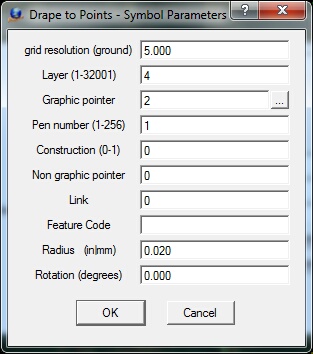
Drape To Points Symbol parameters dialog
High/Low search parameters - Allows the definition of the High/Low point search parameters. See High/Low Point Search Parameters for more information on these variables and the search process.
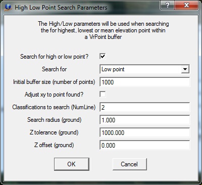
Drape To Points High/Low Search parameters dialog
Local Commands
Local Commands may be keyed-in any time or may be placed in Vr Macros or the Local Args field of a Function Key.
Drape To Points Parameters
Key-in |
Description |
Range |
WsTc= |
Workspaces to consider |
0=Current 1=All open |
CreGri= |
Create grid of symbols before draping |
0=No 1=Yes |
DraLin= |
Drape line points |
0=No 1=Yes |
DraSym= |
Drape symbols |
0=No 1=Yes |
LinLay= |
Layers to search for lines |
|
SymLay= |
Layers to search for symbols |
|
FaiLay= |
Layer for entities that cannot be draped |
0-32001 (0=don't change layers) |
|
|
|
Grid Parameters
Lay= |
Layer number |
1-10001 |
Grp= |
Graphic pointer |
1-60 |
Pen= |
Pen number |
1-256 |
Con= |
Construction flag |
0-1 |
Ngr= |
Non graphic pointer |
32 bit |
Lnk= |
Link number |
32 bit |
Fc= |
Feature code |
48 characters |
Rad= |
Symbol radius |
Inches | Mm |
Rot= |
Symbol rotation |
0-360 degrees |
High/Low Point Search Parameters
HiLo_OnOff= |
Turns on/off High/Low point searching |
0=Off 1=On |
HiLo_Mod= |
Search mode |
0=Search for lowest elevation 1=Search for mean elevation 2=Search for highest elevation |
HiLo_BufSiz= |
Initial buffer size |
Number of points (default=1000) |
HiLo_XyAdj= |
Adjust point to xy position of high or low elevation |
0=Off 1=On |
HiLo_SeaCla= |
Classifications to use when searching |
Number Line (blank=all) |
HiLo_SeaRad= |
Radius to search for points from line point or symbol |
Radius (ground) |
HiLo_ZTol= |
Z tolerance for search for points |
Distance (ground) |
HiLo_Zoff= |
Z offset to add to found elevation |
Distance (ground) |
See High/Low Point Search Parameters for more information on the High/Low search parameters.