Vr Mapping |
ON-LINE REFERENCE DOCUMENTATION CARDINAL SYSTEMS, LLC |
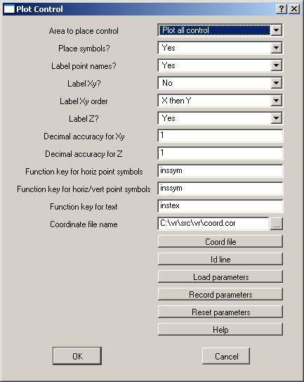
Plot Control (PloCon)
Type: Interactive/Batch Application
Plots and labels a control file into the current VrOne Workspace.
Description
Control may be plotted into the current workspace, all open workspaces or a user-defined window. Functions include symbol and coordinate text label placement.
Local Commands
Key-in |
Description |
Range |
AREA= |
Area to place control |
0 = Current workspace 1 = All open workspaces 2 = Id line |
PLASYM= |
Place symbols? |
0=No 1=Yes |
LABNAM= |
Label point names? |
0=No 1=Yes |
LABXY= |
Label Xy coordinate? |
0=No 1=Yes |
LABXYO= |
Label Xy order |
0=Xy 1=Yx |
LABZ= |
Label elevation? |
0=No 1=Yes |
DECXY= |
Decimal accuracy for Xy label |
0-10 |
DECZ= |
Decimal accuracy for Z label |
0-10 |
FKEYH= |
Function key for horizontal point symbols |
Function key name |
FKEYHV= |
Function key for horizontal/vertical point symbols |
Function key name |
FKEYTEX= |
Function key for text labels |
Function key name |
COOFIL= |
Coordinate file name to retrieve points from |
Coordinate file name |
PARFIL= |
Load parameter file |
Plot control parameter file name (.plc) |
RUN |
Run Plot Control |
None |
Parameters
Area to place control (AREA=)
Defines an area into which to plot control. Options include the current workspace, all open workspaces, or a user defined line.
NOTE: When using options 0 or 1, Pack File (PacVr) should be performed prior to Plot Control to get an accurate workspace boundary.
Place symbols? (PLASYM=)
Specifies whether to place symbols.
Label point names (LABNAM=)
Specifies whether to place coordinate name text labels.
Label Xy coordinate? (LABXY=)
Specifies whether to place coordinate North and East text labels.
Label Xy order (LABXYO=)
Specifies the order to label the X and Y coordinates. Options are "X then Y" or "Y then X". From a key-in, the options are LabXy=0 (X then Y) or LabXy=1 (Y then X).
Label elevation? (LABZ=)
Specifies whether to place coordinate elevation text labels.
Decimal accuracy for Xy label (DECXY=)
Defines the number of places to the right of the decimal point to display for North and East text labels.
Decimal accuracy for Z label (DECZ=)
Defines the number of places to the right of the decimal point to display for elevation text labels.
Function key for horizontal point symbols (FKEYH=)
Defines the function key name for coordinate point symbols that represent horizontal control points.
Function key for horizontal/vertical point symbols (FKEYHV=)
Defines the function key name for coordinate point symbols that represent horizontal and vertical control points.
Function key for text labels (FKEYTEX=)
Defines the function key name to use for coordinate text labels.
Coordinate file name to retrieve points from (COOFIL=)
Defines the coordinate file name from which to run Plot Control. The default file extension for control file is .plc.
Load parameter file (PARFIL=)
Loads the previously defined and saved plot control parameter file.
Run Plot Control (RUN)
Runs the application.
Button Assignments
Find line
When the Id line button is pressed on the Plot Control dialog box, this menu is started. It allows identification of a polygon that defines the area within which to plot control. The Area to place control (AREA=) must be set to Id line (2) for this line to be used when plotting control.
|
Button |
Description |
1 |
Identify line |
Identifies the line within which to plot control. |
2 |
|
|
3 |
|
|
4 |
|
|
5 |
|
|
6 |
|
|
7 |
|
|
8 |
|
|
9 |
|
|
* |
|
|
0 |
|
|
# |
End |
Abandons this menu and returns to Plot Control. |