Vr Mapping |
ON-LINE REFERENCE DOCUMENTATION CARDINAL SYSTEMS, LLC |
Survey Points Out (SurOut)
Type: Translator
Translates VrOne lines and symbols into Survey Points Format.
The Survey Points Format consists of lines and points in comma delimited ASCII file.
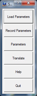
The Survey Points Out button box.
Loads previously recorded Survey Points Out (.spo) parameter file.
Records current translation parameters to a Survey Points Out (.spo) parameter file.
Allows editing of the translation parameters.
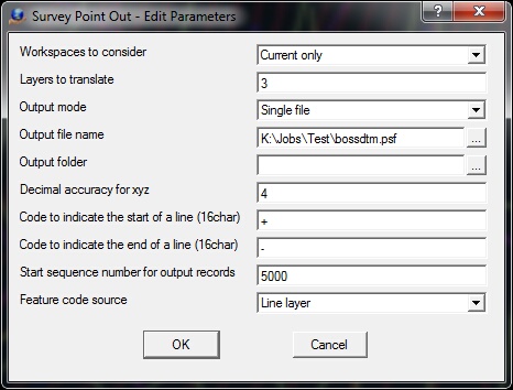
The Edit Parameters dialog box
Workspaces to consider
Defines the workspaces to consider when exporting Survey Points files. Options are "Current only" and "All open".
Layers to consider
Defines the layers in the VrOne file(s) to translate. A Number Line may be used to define these layers.
Output mode
Determines handling of output files during translation.
| • | Single File - All open workspaces are translated into a single Survey Points file. The "Output file name" field determines the output file name. The "Output directory" field may be used to place the output file in a different folder than the VrOne file. |
| • | One File Per Workspace - A Survey Points file is created for each open workspace. The output filename is the same as the workspace (VrOne) filename with an .spf extension. The "Output directory" field may be used to place the output files in a different folder than the VrOne files. |
Output file name
Defines the output file name when "Output mode" is set to "Single File". This name is ignored if "Output mode" is set to "One file per workspace".
Output folder
Defines the folder name to place the output file(s). This field may be left blank to place the output files in same the directory as the VrOne files.
Decimal accuracy for xyz
Defines the number of decimal places for the x, y and z coordinates in the output file(s).
Code to indicate the start of a line (16char)
The start of a line in the output files is defined by this code. The default code is '+'.
Code to indicate the end of a line (16char)
The end of a line in the output files is defined by this code. The default code is '-'.
Start sequence number for output records
Each point or record in the output files much contain a unique number. This parameter defines the start sequence number for the output records. If multiple files are being translated, the number will be sequenced between output files.
Feature code source
The cross referencing between VrOne Layers and Survey Points Format Feature Code is accomplished by using the Vr Function Keys. One of two methods may be used when searching for a point's Feature Code.
| • | Line layer - When the translator needs a Feature Code, the Function Keys are searched for the VrOne layer. When the layer number is found, the Function Key name is used as the Survey Points Feature Code. The Function Key Description is also used as the Survey Points Description or Comment. |
| • | Line point's M flag - The layer number in the line point's M Flag is used to search Function Keys. The Function Key's Feature Code is used as the survey point feature code. The setting of the layer number in a Vr Line point's M Flag is done by another application such as the batch application Drape. |
Begins the file translation process.
Starts the browser and displays the current help document.
Quits Survey Points Out and allows current parameters to be saved if they were altered.
The Survey Points Format consists of lines and points in comma delimited ASCII file. Each record has a unique sequence number, a coordinate position, a feature code, a control code and an optional description.
Following is an example of the Survey Points Format:
5000,553318.7073,1857992.2046,623.8169,BL+/CL
5001,553327.2930,1857901.5110,624.9915,BL
5002,553336.4310,1857813.4315,625.2355,BL
5003,553342.8827,1857744.9807,624.0503,BL-
5004,553498.2773,1857906.8409,621.6160,FN
5005,553436.2169,1857979.3360,645.5678,XLP2
5006,553500.5725,1857929.4577,637.6788,XLP2
5007,553504.7982,1857886.2872,640.6937,XLP2
5008,553511.2007,1857834.5915,643.5109,XLP2
5009,553400.0948,1857886.2190,630.4220,BC
Field |
Example |
Description |
1 |
5000 |
Sequence number |
2 |
553318.7073 |
X coordinate |
3 |
1857992.2046 |
Y coordinate |
4 |
623.8169 |
Z coordinate |
5 |
BL |
Feature code |
6 |
+ |
Control code (see below) |
7 |
/CL |
Description or comment |
Feature Codes
The cross referencing between VrOne Layers and Survey Points Format Feature Code is accomplished by using the Vr Function Keys. One of two methods may be used when searching for a point's Feature Code.
| • | Feature Code Source - Line layer - When the translator needs a Feature Code, the Function Keys are searched for the VrOne layer. When the layer number is found, the Function Key name is used as the Survey Points Feature Code. The Function Key Description is also used as the Survey Points Description or Comment. |
| • | Feature Code Source - Line point's M flag - The layer number in the line point's M Flag is used to search Function Keys. The Function Key's Feature Code is used as the survey point feature code. The setting of the layer number in a Vr Line point's M Flag is done by another application such as the batch application Drape. |
Control Codes
Currently the only control codes that are used are the + (plus) character to indicate the beginning of a line and the - (minus) character to indicate the end of a line.