Vr Mapping |
ON-LINE REFERENCE DOCUMENTATION CARDINAL SYSTEMS, LLC |
Classify 3D (Cla3D)
Type: Interactive Application
Classifies, changes layer, or deletes VrPoints (LiDAR) based on shapes in a 3D stereo environment.
Detailed Description
Classify 3D has the ability to identify VrPoints (LiDAR) based on 3-dimensional shapes such as a cube or an extruded polygon. These identified points may have their classification or layer changed or may be deleted. This interactive application is useful in VrTwo stereo and especially in the VrThree (VrLiDAR) application 3D VrThree.
Once a shape has been defined it may be dragged with the cursor and placed anywhere in the 3D space for point identification.
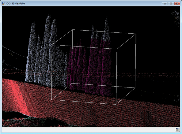
Classify 3D re-classifying points in 3D VrThree using a cube for point identification.
Local Commands
None
Button Assignments
Cube Mode
A 3-dimensional cube is one of the shapes available to identify points. The cube's size is defined by the user by digitizing two corners and by scaling the X, Y or Z axis.
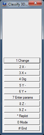
Classify 3D - Cube Menu Keys
1- Change
Changes the points that fall within the current cube location. If Confirm Changes is active, the points will show the change and verification will be required before the points are committed to the database.
2 - X-
Decrements the X axis size of the cube by the Resize Increment.
3 - X+
Increments the X axis size of the cube by the Resize Increment.
4 - Dig
Allows the size of the cube to be digitized with two points.
5 - Y-
Decrements the Y axis size of the cube by the Resize Increment.
6 - Y+
Increments the Y axis size of the cube by the Resize Increment.
7 - Enter Params
Allows the entry/editing of parameters. See Enter Parameters below.
8 - Z-
Decrements the Z-axis size of the cube by the Resize Increment.
9 - Z+
Increments the Z-axis size of the cube by the Resize Increment.
* - Replot
Re-displays graphics.
0 - Mode
Toggle the shape mode between cube and polygon.
# - End
Ends Classify 3D.
Polygon Mode
A 3-dimensional polygon is one of the shapes available to identify points. This polygon is defined by digitizing points in the current 3D environment then specifying an extrusion value for its depth. The depth can be based on the current view projection (3D VrThree) or on the coordinate system Z direction.
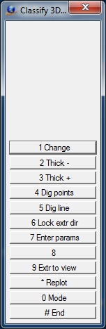
Classify 3D - Polygon Menu Keys
1- Change
Changes the points that fall within the current polygon location. If Confirm Changes is active then the points will show the change and verification will be required before the points are committed to the database.
2 - Thick -
Decrements the thickness (extrusion factor) of the polygon by the Resize Increment.
3 - Thick+
Decrements the thickness (extrusion factor) of the polygon by the Resize Increment.
4 - Dig points
Allows the definition of the polygon by digitizing points in the 3D environment.
5 - Dig line
Allows the definition of the polygon by selecting an existing line in an opened workspace.
6 - Lock ext dir / Unlock ext dir
Locks the extrusion direction so it is not affected by rotating view, or unlocks the extrusion direction so it follows the view again. This only applies when the extrusion direction is set to View. This is useful if you want to see the polygon from another view point without changing the polygon extrusion.
7 - Enter params
Allows the entry/editing of parameters. See Enter Parameters below.
9 - Ext to view / Extr to ground
Toggles between "extrude to view" and "extrude to ground" modes.
* - Replot
Re-displays graphics.
0 - Mode
Toggle the shape mode between cube and polygon.
# - End
Ends Classify 3D.
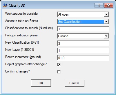
The Classify 3D parameters dialog
Workspaces to consider
Defines the workspaces to consider when identifying points for change. This may be set to "Current only", or "All open".
Action to take on Points
Defines the action to take on the points identified with a cube or polygon.
| • | Set Classification - Changes the points classification number; |
| • | Change Layer - Changes the points layer number; |
| • | Delete - Deletes the points. |
Classifications to search (NumLine)
Defines the classifications to search for when processing VrPoints. Normally points that are displayed are considered but using this parameter allows all points to be displayed while only the classifications defined will be considered for modification. Leaving the field blank will indicate that all VrPoints that are displayed will be considered. A Number Line may be used to define this parameter.
Polygon extrusion plane
Defines the extrusion or thickness plane when using the polygon mode to identify points. A polygon is first digitized then extruded along this plane to create a 3D polygon.
| • | Ground - The extrusion or direction is based on the current coordinate system Z direction; |
| • | View - The extrusion direction is based on the view direction. In 3D VrThree, this view direction is determined by the current 3-dimensional direction from the eye point and may be any angle. |
New Classification (0-31)
If the "Action to take on Points" is defined as "Set Classification", this value is used as the new Classification for the points identified.
New Layer (1-30001)
If the "Action to take on Points" is defined as "Change Layer", this value is used as the new Layer number for the points identified.
Resize increment (ground)
When the current shape is being resized interactively by pressing and holding Vr buttons, this value is used as the positive or negative size increment. The Resize increment is entered as ground units.
Replot graphics after change?
If checked, graphics are updated in real-time after the Change button is pressed.
Confirm changes?
If checked, the change operation must be confirmed by the user before the changes are committed to the database. It is recommended that this option is checked.