Vr Mapping |
ON-LINE REFERENCE DOCUMENTATION CARDINAL SYSTEMS, LLC |
Edit Point (EdiPoi)
Type: Interactive Application
Interactively edits a single VrPoint (LiDAR) in a VrOne workspace.
Detailed Description
Allows interactive, graphical editing of an existing point in a VrOne workspace. Points may be changed, moved, copied or deleted.
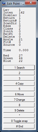
Edit Point Menu Keys dialog
Local Commands
Key-in |
Description |
Range |
LAY= |
Layer number |
1-30001 |
INT= |
Intensity |
0-65535 |
RET= |
Return number |
1-5 |
RE#= |
Number of returns |
1-5 |
SCA= |
Scan direction flag |
0-1 |
EDG= |
Edge flag |
0-1 |
CLA= |
Classification |
0-31 |
SYN= |
Synthetic flag |
0-1 |
KEY= |
Key point flag |
0-1 |
ANG= |
Scan angle |
-90 to 90 |
FLT= |
Flight number |
0-255 |
SOU= |
Point source Id |
0-65535 |
TIM= |
Gps Time |
+/– 1.8e308 |
RED= |
Red image channel |
0-255 |
GRE= |
Green image channel |
0-255 |
BLU= |
Blue image channel |
0-255 |
Layer number (LAY=)
Vr Layer number. Range: 1-30001
Intensity (INT=)
The intensity value is the integer representation of the pulse return magnitude. This value is optional and system specific. Range: 0-65535
Return number (RET=)
The Return Number is the pulse return number for a given output pulse. A given output laser pulse can have many returns which must be marked in sequence of return. The first return will have a Return Number of one, the second a Return Number of two, and so on up to five returns. Range: 1-5
Number of returns (RE#=)
The Number of Returns is the total number of returns for a given pulse. For example, a laser data point may be return two (Return Number) within a total number of five returns. Range: 1-5
Scan direction flag (SCA=)
The Scan Direction Flag denotes the direction in which the scanner mirror was traveling at the time of the output pulse. A bit value of 1 is a positive scan direction and a bit value of 0 is a negative scan direction (where positive scan direction is a scan moving from the left side of the in-track direction to the right side and negative the opposite). Range: 0-1
Edge flag (EDG=)
The Edge of Flight Line data bit has a value of 1 only when the point is at the end of a scan. It is the last point on a given scan line before it changes direction. 1=Point is edge of flight line.
Classification (CLA=)
Point classification. If a point has never been classified, this value must be set to zero. Range: 0-31
NOTE: The Vr database supports a Classification range of 0-255 although the current software complies with the LAS specification of 0-31.
0 |
Created, never classified |
1 |
Unclassified |
2 |
Ground |
3 |
Low Vegetation |
4 |
Medium Vegetation |
5 |
High Vegetation |
6 |
Building |
7 |
Low Point (noise) |
8 |
Model Key-point (mass point) |
9 |
Water |
10 |
Reserved for ASPRS Definition |
11 |
Reserved for ASPRS Definition |
12 |
Overlap Points |
13-31 |
Reserved for ASPRS Definition |
Synthetic flag (SYN=)
If set to 1, this point was created by a technique other than LiDAR collection, such as digitized from a photogrammetric stereo model. Range: 0-1
Key point flag (KEY=)
If set to 1, this point is considered to be a model key-point and thus generally should not be withheld in a thinning algorithm. Range: 0-1
Scan angle (ANG=)
The Scan Angle has a valid range from -90 to +90 and is the angle (rounded to the nearest integer in the absolute value sense) at which the laser point was output from the laser system including the roll of the aircraft. The scan angle is within 1 degree of accuracy from +90 to –90 degrees. The scan angle is an angle based on 0 degrees being nadir, and –90 degrees to the left side of the aircraft in the direction of flight. LAS range: +90 to -90. Vr range: -32767 to 32768
Flight number (FLT=)
User-defined flight number. This attribute is not defined in the LAS specification. Range: 0-255
Point source Id (SOU=)
This value indicates the file from which this point originated. Valid values for this field are 1 to 65,535 inclusive with zero being used for a special case discussed below. The numerical value corresponds to the File Source ID from which this point originated. Zero is reserved as a convenience to system implementers. A Point Source ID of zero implies that this point originated in this file. This implies that processing software should set the Point Source ID equal to the File Source ID of the file containing this point at some time during processing. Range: 0-65535
GPS time (TIM=)
GPS time at which the point was acquired in seconds. This attribute is available in VrPoint formats 1 and 3. Range: -1.8e307 to 1.8e307
Red (RED=)
The red image channel value associated with this point. This attribute is available in VrPoint formats 2 and 3. Range: 0-255
Green (GRE=)
The green image channel value associated with this point. This attribute is available in VrPoint formats 2 and 3. Range: 0-255
Blue (BLU=)
The blue image channel value associated with this point. This attribute is available in VrPoint formats 2 and 3. Range: 0-255
Button Assignments
Edit Point - Lock On
|
Button |
Description |
1 |
Id point |
Identifies point to edit |
2 |
|
|
3 |
|
|
4 |
|
|
5 |
|
|
6 |
|
|
7 |
|
|
8 |
|
|
9 |
|
|
* |
|
|
0 |
|
|
# |
End |
Ends application |
Edit Point - Main
|
Button |
Description |
1 |
Search |
Saves the current point and returns to Lock on |
2 |
|
|
3 |
|
|
4 |
Copy |
Copies point |
5 |
|
|
6 |
Move |
Moves point |
7 |
Change |
Allows changing of point attributes using a dialog box |
8 |
|
|
9 |
Delete |
Deletes the current point after verification |
* |
|
|
0 |
Toggle snap |
Toggles snap on/off |
# |
End |
Ends application |
Pressing button 7 (Change) displays the following dialog which allows the modification of the current point's attributes.
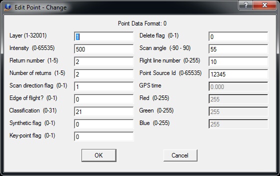
Edit Point Change dialog
Each VrOne file uses one of the four Point Data Formats. These formats are based on the LAS specified data formats. The current Point Data Format number is displayed at the top of this dialog and attributes that are not supported by the current format are dimmed. See Parameters above for information on each attribute presented in this dialog.