Vr Mapping |
ON-LINE REFERENCE DOCUMENTATION CARDINAL SYSTEMS, LLC |
Grid In (GriIn)
Type: Translator
Translates grid point (GridFloat) formatted files to VrPoints in VrOne files.
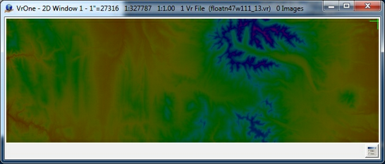
The Grid In translator converts points in from a grid file to the Vr Mapping database as Vr Points. The GridFloat format is supported by this translator in either binary or ASCII formats. More information of the GridFloat format can be found at
http://www.digitalpreservation.gov/formats/fdd/fdd000422.shtml
http://www.digitalpreservation.gov/formats/fdd/fdd000421.shtml
The grid formatted file only stores the point elevations. Grid parameters such as the origin, grid spacing and number of rows and columns are stored as the file header (ASCII format) or in a separate header file (binary format). The grid file header file has a file extension of .hdr and the grid data file has a file extension of .flt.
During translation, the coordinates may be re-projected to a different coordinate system by defining the coordinate system of the "Translation Out Projection" and coordinate system of the VrOne file(s). See Coordinate Projections for more information.
Information on translating Digital Terrain Elevation Data (DTED) files and National Elevation Dataset (NED) files can be found at the end of this document.
The Grid Out (GriOut) translator exports grid point data.
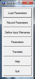
Loads previously recorded Grid In (.gri) parameter file.
Records current translation parameters to a Grid In (.gri) parameter file.
Allows Points input files to be selected. Also allows a VrOne output file to be defined for each input file. Looks for files with an extension of .flt by default, but attempts to read in any file chosen.
The VrOne output filenames are only used if the "Translate to separate VrOne files" option is on.

The Define Input Filenames dialog box
| • | Add Files - Displays a standard VrOne file selection dialog. All files selected are added to the list of Input files. Generates a VrOne output filename based on each input filename. |
| • | Remove All - Removes all files from the Input file table. |
| • | Change Output Directory - Allows changing the output directory (folder). By default, the output directory is the same as the input file directory. |
Allows the entry and editing of translation parameters.
The Edit Parameters dialog Box
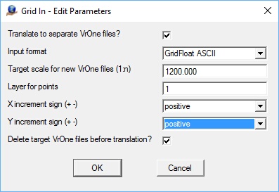
Translate to separate VrOne files?
Determines whether the grid input files are translated to a separate VrOne files. The Input to Output filename cross-reference is set in the "Define Input Filenames" dialog.
Input format
Defines the format of the input files.
| • | GridFloat binary - The input format is binary with each elevation being represented by a four-byte floating point number. When using this format, the header information is saved in a separate ASCII file. This file has the same name as the data file but with a .hdr file extension. |
| • | GridFloat ASCII - The input format is ASCII (text). The header information is in the beginning of each data file |
Target Scale for new VrOne files (1:n)
Defines target scale to use when creating the new VrOne file if the "Translate to separate VrOne files?" is on and a VrOne file does not exist during translation.
Layer for points
Specifies layer into which to place translated points.
X increment sign (+-)
Typically the origin X coordinate is to the left and is the smallest X value in the resulting file. Setting this parameter to negative makes the origin X coordinate to the right, making it the largest X value in the resulting file. This, in effect, mirrors the X axis.
Y increment sign (+-)
Typically the origin Y coordinate is to the bottom and is the smallest Y value in the resulting file. Setting this parameter to negative makes the origin Y coordinate to the top, making it the largest Y value in the resulting file. This, in effect, mirrors the Y axis.
Delete target VrOne files before translation?
If this option is checked each target VrOne file will be deleted before translation if it exists. If this option is unchecked and the target VrOne file exists, the new data will be appended to the file. This parameter is considered only if the "Translate to separate VrOne files" option is checked.
Begins the file translation process. All files that were defined by the “Define input Filenames” option are imported.
Starts the browser and displays the current help document.
Quits Points In and allows current parameters to be saved if they were altered.
Translating Digital Terrain Elevation Data (DTED) Files
Digital Terrain Elevation Data (DTED) files can be translated by first converting the DTED files to Grid Float ASCII files. Since DTED files are grid files similar to the Grid Float files, the conversion is straightforward. This conversion can be performed by using the Geospatial Data Abstraction Library (GDAL) application gdal_translate which is provided with the installation of Vr Mapping. gdal_translate is run from a Command Prompt window.
Following are the steps to convert a DTED file to a Grid Float ASCII file.
Open a Command Prompt window
Type 'cmd' in the Windows search field from the Start button.
Set an environment variable.
This step needs to be done only after opening the Command Prompt Window
> c:\vr\bin\gdal_translate\gdal_translate_setenv
Move to the folder containing the DTED files
> cd \jobs\DTEDfolder
(DTEDfolder is used as an example. You folder name will be different)
Translate DTED file to Grid Float ASCII file
> gdal_translate -of AAIGrid DTEDfile.dt0 GridFloat.flt
where:
gdal_translate - The translation program
-of AAIGrid - Specifies the output format
DTEDfile.dto - The DTED input file name to be translated. (DTEDfile.dto is used as an example. Your file name will be different)
GridFloat.flt - The Grid Float output file name. (GridFloat.flt is used as an example. Your file name will be different)
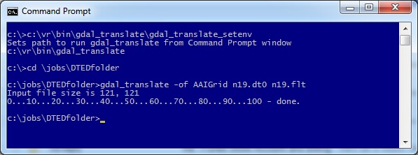
Example conversion of DTED file n19.dt0 to Grid Float ASCII file n19.flt
Translating National Elevation Dataset (NED) Files
National Elevation Dataset (NED) files are grid formatted files and are similar to Grid Float files. NED files can be in several formats including DEM, DXF, GeoTIFF, ASCII XYZ and Arc ASCII. Most of these formats, such as ASCII XYZ, are supported by one of the Vr Mapping translators. If the NED input format is not supported by Vr Mapping it should be able to be converted to a supported format using the GDAL gdal_translate program.
Grid In (GriIn)
- Added March 2016 - Version 05.07.30
- Revised July 2017 - Version 05.09.00