Vr Mapping |
ON-LINE REFERENCE DOCUMENTATION CARDINAL SYSTEMS, LLC |
Grid Out (GriOut)
Type: Translator
Translates VrPoints in VrOne files to grid point (GridFloat) formatted files.
The Grid Out translator converts points in the Vr Mapping database as Vr Points to grid files. The GridFloat format is supported by this translator in either binary or ASCII formats. More information of the GridFloat format can be found at
http://www.digitalpreservation.gov/formats/fdd/fdd000422.shtml
http://www.digitalpreservation.gov/formats/fdd/fdd000421.shtml
The grid formatted file only stores the point elevations. Grid parameters such as the origin, grid spacing and number of rows and columns are stored as the file header (ASCII format) or in a separate header file (binary format). The grid file header file has a file extension of .hdr and the grid data file has a file extension of .flt.
Information on translating to Digital Terrain Elevation Data (DTED) files and National Elevation Dataset (NED) files can be found at the end of this document.
The Grid In (GriIn) translator imports grid point data.
Loads previously recorded Grid Out (.gro) parameter file.
Records current translation parameters to a Grid Out (.gro) parameter file.
Allows editing general translation parameters.
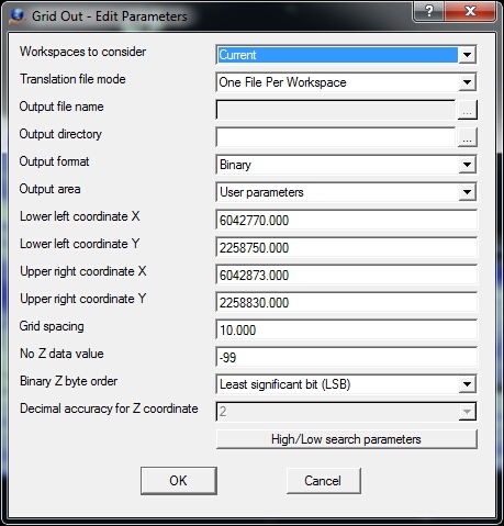
The Edit Parameters dialog Box
Workspaces to consider
Defines the workspaces to consider when running exporting grid files. Options are "Current workspace" or "All open workspaces".
Translation file mode
Determines handling of output files during translation.
| • | Single File - All open workspaces are translated into a single grid file. The "Output file name" field determines the Points file name. |
| • | One File Per Workspace - A grid file is created for each open workspace. The grid filename is the same as the workspace (VrOne) filename with a .flt extension. The "Output directory" field may be used to place the grid files in a different folder than the VrOne file. |
Output file name
Defines the output file name when "Translation file mode" is set to "Single File". This name is ignored if "Translation file mode" is set to "One file Per Workspace".
Output directory
Defines output directory if not using "Single File" translation mode. This field may be left blank to place the grid files in same the directory as the VrOne files. This field is ignored if the "Translation file mode" is set to "Single File".
Output format
Defines the format of the output files.
| • | Binary - The output format is binary with each elevation being represented by a four-byte floating point number. When using this format, the header information is saved in a separate ASCII file. This file has the same name as the data file but with a .hdr file extension. |
| • | ASCII - The input format is ASCII (text). The header information is in the beginning of each data file |
Output area
Determines how the output area is defined. Options are "User parameters" or "File boundary". With either option, the bounding coordinates are rounded to an even grid spacing value.
| • | User parameters - The lower left and upper right coordinates are defined by the user and are the following four parameter fields. This is useful when writing a single grid file. |
| • | File boundary - The boundary of the VrOne file determines the output area. |
Lower left coordinate X
X coordinate position of the lower left corner of the area to cover. (ground)
Lower left coordinate Y
Y coordinate position of the lower left corner of the area to cover. (ground)
Upper right coordinate X
X coordinate position of the upper right corner of the area to cover. (ground)
Upper right coordinate Y
Y coordinate position of the upper right corner of the area to cover. (ground)
Grid spacing
Distance between grid points in the X and Y direction. The grid spacing is the same for the X and Y axis. (ground)
No Z data value
Since the output data file contains only elevations, if an Z value cannot be determined at a XY location this value will be used as a place holder. (default=-9999)
Binary Z byte order
If the output format is binary, this parameter specifies the bit order of the elevations in the file. The options are "Most significant bit (MSB)" and "Least significant bit (LSB)". Windows typically use LSB and UNIX and Linux typically use MSB.
Decimal accuracy for Z coordinate
If the output format is ASCII, this parameter specifies the decimal accuracy of the elevations in the ASCII output file. (default=3)
High/Low search parameters
When draping the XY grid positions onto the points, the High/Low search parameters are used to determine elevations. See High/Low Point Search for more information.
Begins the file translation process.
Starts the browser and displays the current help document.
Quits Grid Out and allows the current parameters to be saved if they were altered.
Translating To Digital Terrain Elevation Data (DTED) Files
Grid Float files can be translated to Digital Terrain Elevation Data (DTED) files. Since DTED files are grid files similar to the Grid Float files, the conversion is straightforward. This conversion can be performed by using the Geospatial Data Abstraction Library (GDAL) application gdal_translate which is provided with the installation of Vr Mapping. gdal_translate is run from a Command Prompt window.
Following are the steps to convert a DTED file to a Grid Float ASCII file.
Open a Command Prompt window
Type 'cmd' in the Windows search field from the Start button.
Set an environment variable.
This step needs to be done only after opening the Command Prompt Window
> c:\vr\bin\gdal_translate\gdal_translate_setenv
Move to the folder containing the Grid Float files
> cd \jobs\DTEDfolder
(DTEDfolder is used as an example. You folder name will be different)
Translate Grid Float file to DTED file
> gdal_translate -of DTED GridFloat.flt DTEDfile.dt0
where:
gdal_translate - The translation program
-of DTED - Specifies the output format
GridFloat.flt - The Grid Float output file name. (GridFloat.flt is used as an example. Your file name will be different)
DTEDfile.dto - The DTED input file name to be translated. (DTEDfile.dto is used as an example. Your file name will be different)
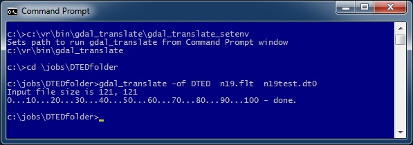
Example conversion of Grid Float ASCII file n19.flt to DTED file n19test.dt0
Translating to National Elevation Dataset (NED) Files
National Elevation Dataset (NED) files are grid formatted files and are similar to Grid Float files. NED files can be in several formats including DEM, DXF, GeoTIFF, ASCII XYZ and Arc ASCII. Most of these formats, such as ASCII XYZ, are supported by one of the Vr Mapping translators. If the desired NED output format is not supported by Vr Mapping then it should be possible to convert a Grid Float file to the required NED format using the GDAL gdal_translate program.
Grid Out (GriOut) added March 2016 - Version 05.07.30