Vr Mapping |
ON-LINE REFERENCE DOCUMENTATION CARDINAL SYSTEMS, LLC |
Vr Aerial Triangulation (VrAirTrig)
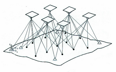
Vr Aerial Triangulation (VrAirTrig) with VrAdjust is a stand-alone program for the collection and processing of aerial triangulation data
VrAirTrig adheres to the standard Cardinal Systems' philosophy: "easy to learn, easy to use, and affordable". The project management tool helps manage large jobs with the speed and flexibility needed for maximum efficiency in production.
This innovative program enables the technician to lay out images of the complete project and to display all readings as either "to be read" or "completed". VrAirTrig's intuitive interface allows the setup, reading, and export of aerial triangulation measurements on up to 2000 images of unlimited size.
This application allows the collection of strip and tie points on a large number of images and performs a block adjustment using aerial triangulation methods. The Aerosys adjustment software is integrated directly with VrAirTrig to perform seamless adjustments. Several third party adjustment packages may also be used through an export and import mechanism.
Points may be measured with any of three methods: Mono-comparator, Semi-automatic correlation assist, and Stereo. Each method is described in more detail in the VrAirTrig documentation.
AeroSys Settings and Configuration